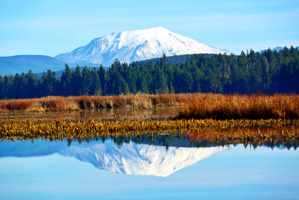
Mt St Helens is best known for its volcanic eruption in 1980, when it blanketed the state with ash and blew off its top.
The eruption transformed the mountain landscape and left behind a blast zone scarred from the eruption landslides and lava flows: what is now Mt St Helens National Monument, a 110,000-acre protected area.
Hiking around Mt St Helens is the best way to experience the dramatic consequence of the eruption and how nature has reestablished itself.
Here are our favorite Mt St Helens hikes, all suitable for a day hike (climbing Mt Helens Helens herself will require another post!). However, some have camping spots available if you’d like to do an overnighter as well.
Easy Mt St Helens Hikes
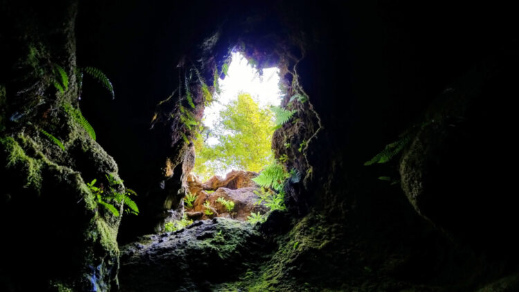
Ape Caves
Some links in this post may be affiliate links. If you make a purchase through one of these links, we may earn a small commission at no extra cost to you. Please see our disclosure policy for more detail.
Driving Directions: Take SR 503 from I-5, continue straight on Spur 503, then continue as it becomes FR 90. At 2.5 miles from the bridge crossing, turn left onto FR 83, then 2 miles to a left on FR 8303. At the end of this road is the parking lot and Ape Headquarters Center.
Distance: 3 miles
Elevation: 350 feet
Difficulty: Easy (however, requires climbing and maneuvering tight spaces, so not good for the claustrophobic or those with mobility limitations)
The Ape Caves trail explores a lava tube within the mountain, giving an inside look at the volcano. The lava tubes hold all sorts of unique features, including cave “slime” on the walls, an important food source for cave-dwelling creatures; a formation known as the “Meatball”; and even a skylight in the lava tube looking to the forest above.
Since this Mt St Helens trail goes through a cave system, make sure you bring a light so you can see the path and all of the interesting features in the lava tubes.
From the parking lot, there is a short distance through the forest before you reach the cave entrance.
From here, the trail is best experienced going downhill – entering the caves through the Upper Cave system, then exiting out the Lower Caves.
The Upper Caves are significantly more rugged and require more agility and uneven terrain, and this direction presents the rocky debris first, allowing hikers to immediately turn back and skip the Upper Caves if not comfortable proceeding. The most difficult part of the Upper Caves is a climb over an 8-foot lava flow.
If skipping the Upper Caves, hikers can still explore the Lower Caves – a more accessible and spacious lava tube that is also fascinating, and another wonderful Mt St Helens hiking spot!
Hummocks Trail
Driving Directions: Take Highway 504 east for 43 miles past Castle Rock. Take a right onto the road toward Johnson Ridge Visitor Center and continue for two miles until you reach the trailhead for the Hummocks Trail/Boundary Trail.
Distance: 2.3 miles
Elevation: 100 feet
Difficulty: Easy
The Hummocks Trail gets its name from the “hummocks” – the small hills/mounds that ended up here after they slid off of the former summit of Mt St Helens in the landslide from the 1980 eruption.
These small hills have even been mapped back to their original position on the mountain.
Besides the hummocks, this trail also explores the recovering forest and wetlands that have reemerged since the eruption.
Due to the sensitive nature of this area, it is especially important to remain on the trail, and pets are not allowed on this particular hike in Mt St Helens National Monument.
Moderate Mt St Helens Hikes
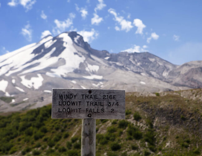
Loowit Falls
Driving Directions: From the town of Randle, take SR 131 south for two miles to FR 25. Drive 18 miles along this road until you reach FR 99, and take this road for 17 miles until you reach the Windy Ridge Viewpoint.
Distance: 8 miles
Elevation Gain: 1200 feet
Difficulty: Moderate
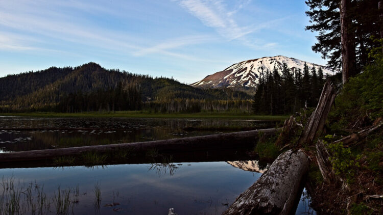
Loowit Falls is a glacier-fed waterfall in a volcanic and bare landscape that reminds you of the history of the landscape here.
The trail proceeds from the Windy Ridge Viewpoint down the service road then heads right onto the Windy Trail.
This Mt St Helens hiking trail begins lined with wildflowers and alders, but as you proceed into the blast zone this quickly changes into a rugged volcanic landscape.
In addition to the waterfall, the trail also overlooks several vistas of the mountain and visitors often catch a glimpse of mountain goats along the trail.
Harry’s Ridge
Driving Directions: This trail begins at the Johnson Ridge Visitor Center and Observatory. To reach Johnson Ridge, take highway 504 east from Castle Rock. Follow the signs along 504 towards the Johnson Ridge Visitor Center. The visitor center and trailhead are at the end of Highway 504.
Distance: 8 miles
Elevation: 200 feet
Difficulty: Moderate
The wildflowers that line Harry’s Ridge is the spring and summer are magnificent colors in contrast to the volcanic landscape.
The trail also features views of the crater, which still is still actively smoking and erupting to this day.
The trail starts on a paved path that follows switchbacks up the hill to an overlook, then downhill along the ridge. A junction a mile and a half from the start bypasses a sketchy traverse and continues up and along the ridge.
At about 3 miles the trail reaches the junction with the Harry’s Ridge trail – follow the trail to the right. You will reach high point along the ridge in another mile.
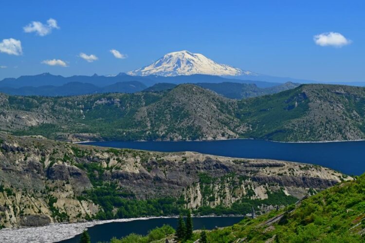
From the top of this trail, you will be impressed with the views of St. Helens and Spirit Lake below. While looking out on Spirit Lake, see if you can spot the logs moving in the wind; their movement often changes the shape of the lake.
Truman Trail – Pumice Plains

Driving Directions: To reach the Windy Ridge trailhead, on the eastern side of this trail, drive on Forest Road 25 from the town of Randle until you reach the junction with Forest Road 99. Turn onto 99 and continue until the end of the road.
Distance: 10 miles
Elevation: 200 feet
Difficulty: Moderate
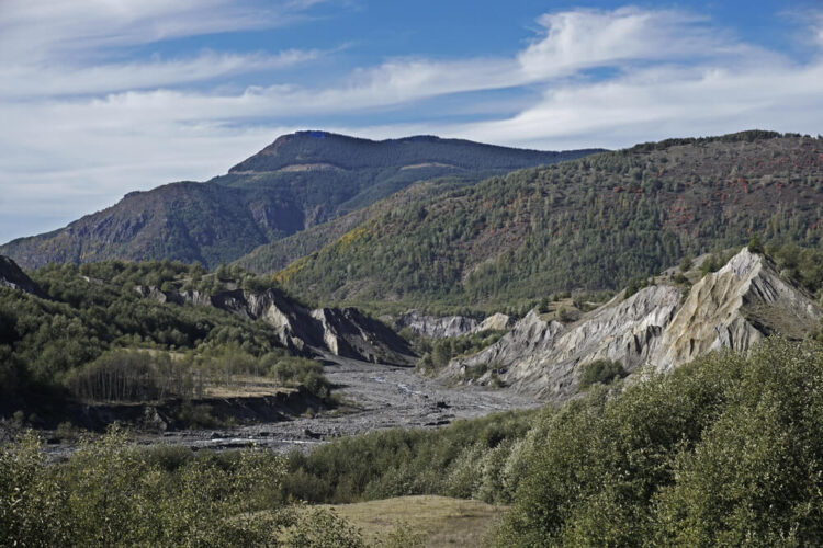
This Mt St Helens trail explores the pumice plains formed from the eruption, an odd combination of flat plains lands and ash-formed hills.
This area was very affected by the eruption, but is now full of plants and wildlife, which have re-inhabited the area since the eruption. You may encounter mountain goats, elks, and many species of birds on your hike.
The Truman Trail has two possible starting points – either from Windy Pass and hiking east, or from Johnson Ridge Observatory, and hiking west. Starting from the Johnson Ridge Observatory makes for a longer hike.
Goat Mountain / Deadman’s Lake
Driving Directions: Beginning at the town of Randle, take Forest Road 25 for 9 miles until you reach the bridge at the Cispus River. Here, just after the bridge crossing, take a right onto Forest Road 26. Continue for 12 miles until you reach Forest Road 2612, then continue another 0.5 miles to the Goat Mountain trailhead. Forest Road 26 is unpaved and can be rough but is generally passable with careful driving.
Distance: 11 miles
Elevation: 2,400 feet
Difficulty: Moderate
The trail to Goat Mountain and Deadman’s Lake is a fantastic hike for late summer or early fall, when the trail is lined with ripe huckleberries. This is a hidden gem, and it is unlikely you will see many people out here.
Earlier in the summer, it can be home to thickets of mosquitos, which may make for a less-pleasant experience.
Although the trail begins with a climb, once you reach the ridge, the grade evens out, and the trail is lined with enough mountain views to distract any tired hiker.
The trail does not go up the summit of Goat Mountain, but this makes a nice addition for even better views if you have the energy to spare. There is no formal trail up to the summit, so tread lightly to avoid stomping the alpine vegetation.
Past Goat Mountain, the trail descends 500 feet down to Deadman’s Lake, a nice mountain lake surrounded by forest.
For those who want to extend their adventure, this can be combined into a loop with the Green River Trail (below), for a wonderful overnight adventure.
Green River Trail
Driving Directions: Beginning at the town of Randle, take Forest Road 25 for 9 miles until you reach the bridge at the Cispus River. Here, just after the bridge crossing, take a right onto Forest Road 26. Continue for 12 miles until you reach Forest Road 2612, then continue another 2.5 miles. Take the curve left at the next intersection with the signed trail crossing the road. Forest Road 26 is unpaved and can be rough but is generally passable with careful driving.
Distance: 7.2 miles
Elevation: 940 feet
Difficulty: Moderate
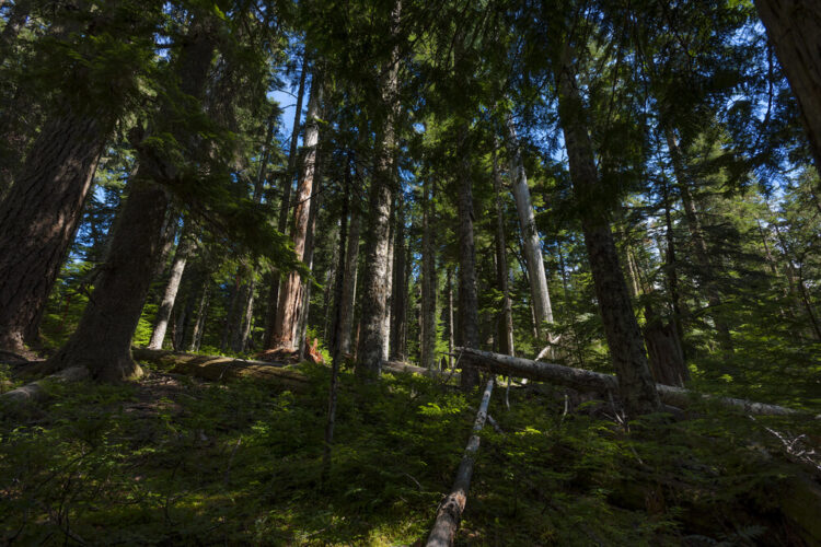
This trail features one of the most untouched old-growth forests in existence within Washington.
This tract of land is owned by Weyerhaeuser but was protected from logging unlike some of the surrounding slopes, and the difference is breathtaking. The trees along this trail are truly old giants.
The vegetation along this trail is incredible, as every surface is layered with multiple downed logs, thick moss, mushrooms, ferns, and bushes.
The old growth forest begins at 2.5 miles from the trailhead; so a 7.2 mile hike will take you one mile deep into the old trees. The biggest trees are further down the trail, between milepost 3.5 and 5.5.
The trail continues past milepost 5.5 for another 3 miles if you are eager to extend your Mt St Helens hike even further.
There are plenty of campsites along this trail, making for a wonderful overnight trip in the beautiful forest.
Read Next

Washington Hikes Bucket List: 21 Best Hikes in Washington State
Hikes Near Seattle: The 11 Best Day Hikes Near Seattle
Hikes in Olympic National Park: 7 Unforgettable Hikes in Olympic National Park
Hikes in North Cascades National Park: 15 Best North Cascades Hikes
Hikes in Mt Rainier National Park: 7 Incredible Hikes in Mt Rainier National Park