

The Mountain Loop Highway is the access point to some of the best hikes in the state – with rugged and remote peaks visible from the summits and viewpoints along this highway.
Located north of Highway 2, the Mountain Loop travels through the southern region of the North Cascades, from Granite Falls to Arlington.
Any of the hikes off Mountain Loop Highway are worth a visit, but here’s a list of some of my favorites to help you narrow it down.
Easy Mountain Loop Highway Hikes
Monte Cristo Ghost Town
Some links in this post may be affiliate links. If you make a purchase through one of these links, we may earn a small commission at no extra cost to you. Please see our disclosure policy for more detail.
Driving Directions: Drive 31 miles east along the Mountain Loop Highway from Granite Falls. Parking for this trail is located at the Barlow Pass parking lot, and the trail begins on the gated road across the street.
Distance: 8 miles
Elevation Gain: 700 feet
Rating: Easy
A hike to the Monte Cristo Ghost Town is a fascinating journey back into the history of the region.
The Mountain Loop Highway in Washington’s Cascade Mountains was constructed for use in transporting mining goods between the remote mines in these mountains and the port towns along the water.
On this hike, you will be able to see this history. The trail begins on an old road to access the mining town and follows it for much of the way to the ghost town.
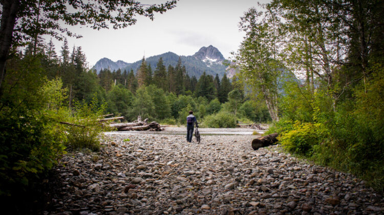
The log crossing across the South Fork Sauk River is a reminder of the previously existing bridge here on the road, a bridge that cannot be rebuilt today due to Snohomish County regulations.
The hike in is nice, but the most fascinating part of this hike is exploring the few remaining relics of the mining town. There are several remaining buildings, old mine equipment, and many indications of the recent environmental cleanup of the old mine tailings.
This is also a great location for a beginning backpacking trip. The relatively easy hike in, the fun places to explore in the ghost town, and the abundance of camping sites make it great for a wide range of hikers looking to explore some Mountain Loop Highway trails.
Old Robe Canyon

Driving Directions: Drive east along the Mountain Loop Highway for 7 miles from Granite Falls. The trail begins at an old brick sign on the right side of the highway, across from Forest Road 41. Parking is along the side of the highway.
Distance: 2.5 miles
Elevation Gain: 350 feet
Rating: Easy
This trail is one of my favorite trails for any day that is slightly wet or cloudy, as the main feature of the trail is the trail-adjacent river, too close to hide in clouds. Unless, of course, it is that kind of day – in which case I would recommend staying cozy inside.
This trail follows the former route of railroad tracks built to transport mined ore from Monte Cristo to Everett. This did not prove to be a good choice of location, as many landslides and flood frequently destroyed the tracks. The trail ends at a present-day rockslide, and due to the unstable terrain further down the canyon, travel past this point is prohibited.
Luckily, the trail up to this point was built by a scout troop in the 1960s (including my grandfather!) and is still maintained to allow visitors to enjoy it today.
The trail is short, but sweet – heading down to the canyon where it follows the river until the end. The rapids along this stretch of canyon are particularly impressive, as are the canyon walls.
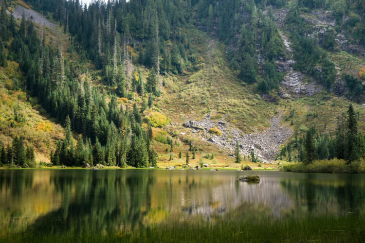
Heather Lake
Driving Directions: Drive for 11 miles past Granite Falls until you reach Mt Pilchuck Road. Take a right on the road and continue for 1.5 miles to the Heather Lakes parking lot. ‘
Distance: 4.6 miles
Elevation Gain: 1,035 feet
Rating: Easy
Heather Lake is a pretty lake underneath Mt Pilchuck, with a relatively short hike to reach it. This hike is fairly flat, as it follows an old logging road for part of the route. On either end of the forest road there is some climbing, as you do have some elevation to gain on this trail.
The route is generally characterized by muddy wetlands, with lots of boardwalks built to avoid the muddy trail problems. As you continue upwards and the forest thins out, you may also see some of the beautiful wildflowers that grow here.
Views at the lake are made more impressive by the looming presence of Mt Pilchuck in the background – another hike I recommend along the Mountain Loop Highway.
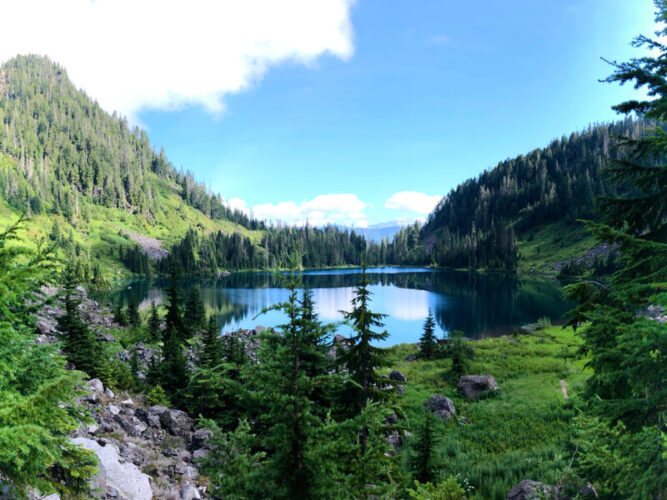
Lake 22
Driving Directions: The trailhead is located 13 miles east of Granite Falls along the Mountain Loop Highway.
Distance: 5.4 miles
Elevation Gain: 1,350 feet
Rating: Easy
One of the best-loved lake trails off the Mountain Loop Highway, be sure to arrive early to secure parking, since this parking area fills up quickly on weekends.
Lake 22 is the closest place you will find to a rainforest in the Cascade Mountains, which are not technically a rainforest. However, water and general dampness are present all along this trail, making the vegetation especially green and luscious.
The trail here passes through impressively large hemlock and cedar trees – remaining tracts of old-growth forest. In case you’re not impressed enough with the large trees, at 1.5 miles, the trail leaves the forest for a bit and grants magnificent mountain views.
The trail then returns to the forest and continues to the lake. Here, the views of Mt Pilchuck towering over the lake make this hike even more impressive.
Moderate Mountain Loop Highway Hikes
Mt Pilchuck

Driving Directions: Drive for 11 miles past Granite Falls until you reach Mt Pilchuck Road. Take a right on this road and continue for 7 miles to the trailhead.
Distance: 5.5 miles
Elevation Gain: 2,300 ft
Rating: Moderate
This North Cascades Mountain Loop Highway trail is relatively short compared to the effort it takes to reach other similar summits in the area. Thanks to this accessibility, the trail can be quite crowded, and is another hike where it is beneficial to start early and avoid the crowds.
Although the trail is moderate in difficulty, this trail requires some route-finding, since although there is a trail to the summit, it is easy to wander off trail and head the wrong direction. The trail also presents some early season hazards, making it a better hike to save for the end of July and August.
At the top there are breathtaking 360-views to admire (or so I’ve been told; every time I go the clouds are thick), and a historic fire lookout.
Difficult Mountain Loop Highway Hikes
Green Mountain

Driving Directions: The trailhead is also accessible from the Mountain Loop Highway, but the route described here coming from the other direction is quicker if you are coming from Darrington. Drive north from Darrington along Highway 530 for 7 miles, then turn right onto Suittle River Road. Follow this road until it becomes Green Mountain Road at a slight left, then continue until the parking area at the end of the road.
Note: This road can be rough so check conditions before driving if you are unsure.
Distance: 8.5 miles
Elevation Gain: 3,300 feet
Rating: Difficult
This trail is known as one of the finest in the state, although it comes at a cost – a steep trail and a rough road. However, the views are spectacular, and trail ends at a well-kept historic fire lookout.
The green meadows on this mountain are truly unique and can be seen as soon as the trail emerges from the forest switchbacks.
During springtime, the meadows take on an even darker shade of green, in summer, the meadows are filled with blooming wildflowers (making it one of the best wildflower hikes in Washington!), and in the fall, the patches of heather turn bright red.
When you reach the top, you will be greeted both by the 360-degree views of the surrounding peaks and the resident marmot – known as “The Greeter”. This marmot spends their day whistling at visitors who make it up this far – accept it either as a nice welcome or an angry warning – but either way, enjoy your accomplishment.
Mt Dickerman

Driving Directions: From Granite Falls, drive for 27 miles east on the Mountain Loop Highway until you reach the Mt Dickerman trailhead and parking lot.
Distance: 8.2 miles
Elevation Gain: 4,000 feet
Rating: Difficult
This trail exemplifies the hikes of this region as you traverse the trail to the summit of Mt Dickerman. The trail is difficult, but achievable for the determined and moderately-conditioned hiker – as I can tell you from experience accompanying many such hikers to the top!
The route to the top begins with switchbacks through the forest, on a moderately-graded trail. Within two miles, the trees begin to thin, and the trail emerges into the more open meadows that characterize this mountain.
A little further up, huckleberries grow in huge quantities, making for the perfect rest stop in the fall when the berries are ripe
Once you arrive at the top, you will be blessed with breathtaking views of the many nearby summits and the further peaks.
Read Next
Hikes Near Seattle: 11 Epic Hikes Near Seattle
North Cascades National Park: 15 Incredible North Cascades Hikes
Wildflower Hikes: 15 Beautiful Wildflower Hikes in Washington State
Fall Hikes: 9 Best Fall Hikes in Washington State

