
Journeying to some of the best waterfalls in Washington will lead you all over this beautiful state.
You’ll traverse through the Columbia River Gorge, into the Olympic, Mount Rainier, and North Cascades National Parks, and head towards eastern Washington for the scenic Palouse Falls.
With over 3,000 named waterfalls, Washington is home to some of the most beautiful falls in the country.
We have narrowed your search to some of the best waterfalls in Washington State to make your job a little easier: all you have to do is pick some and get there!
Take to the trails or view from the scenic overlooks available by car as you venture through Washington on a waterfall adventure.
Listed below is all the pertinent information on 11 of our favorite waterfalls!
Best Waterfalls in Washington State
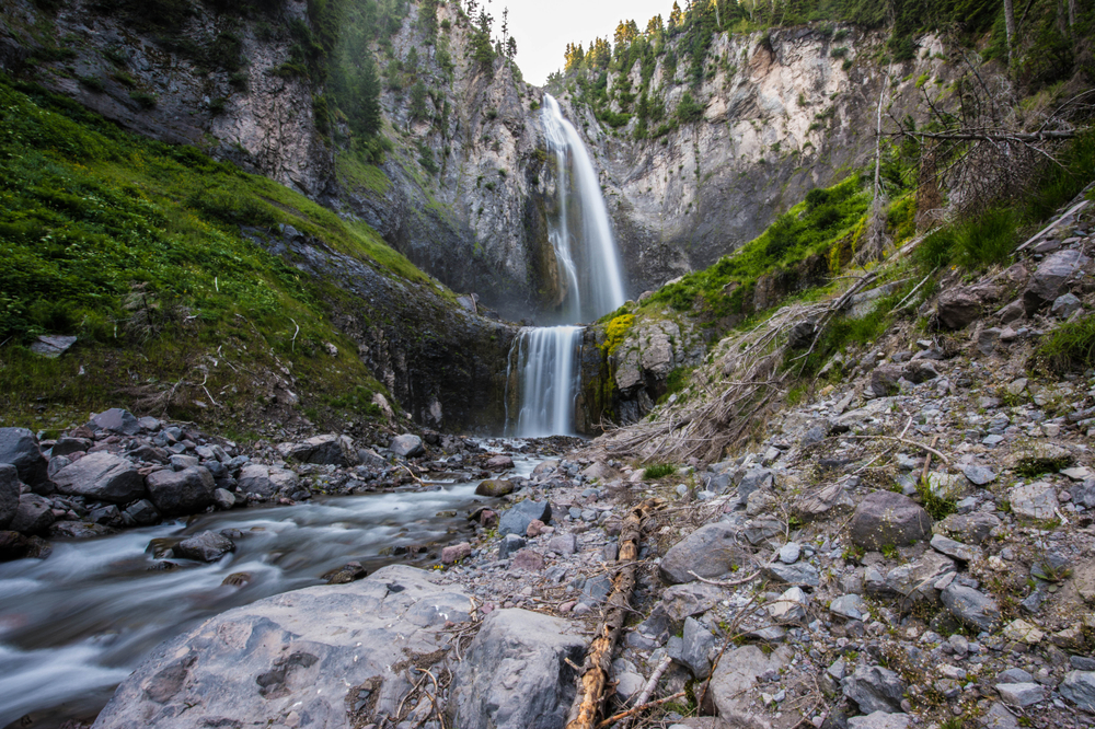
Comet Falls
Some links in this post may be affiliate links. If you make a purchase through one of these links, we may earn a small commission at no extra cost to you. Please see our disclosure policy for more detail.
Location: Mount Rainier National Park
Trail Length: 1.9 miles each way, with an uphill switchback climb to the falls
Elevation change: 1,250 feet
Height of Waterfall: 320 feet
Parking Pass: National Park Pass
Pet-Friendly Trail: No
Best Photo Location: From the 2nd or 3rd switchback, take the Spur Trail to the waterfall’s base
The fall is one of the most beautiful waterfalls in Mount Rainier National Park and indeed all of Washington State.
The Comet Falls Trail leads past several cascades along Van Trump Creek and the beautiful Van Trump Falls.
The three-tiered Van Trump Falls is 200 feet before Comet Falls: so you can tick off two beautiful Washington waterfalls from your bucket list in one hike!
Falls Creek Falls

Location: Columbia River Gorge
Trail Length: 5 miles round trip
Elevation change: 1,100 feet
Height of Waterfall: 335 feet
Parking Pass: Not needed
Pet-Friendly Trail: Yes, on leash
Best Photo Time: Early morning or late afternoon
This waterfall is particularly special as the hike to it is just as beautiful as the destination!
On the way, you’ll cross a beautiful suspension bridge high over Falls Creek that is simply breathtaking, especially if you’re lucky enough to hike it in the fall (though spring will bring the most powerful water flow).
The beautiful Falls Creek Falls has three tiered sections, and when you complete the hike, you arrive at the lower section of the falls with a partial view of the other cascades.
You can stop at this viewpoint or scramble below or hike above for other angles of the waterfall.
Lewis River Falls

Location: Lewis River Region, Southwest Washington
Trail Length: 8.6 miles round trip
Elevation change: 450 feet
Height of Waterfall: Lower Falls – 43 feet, Middle Falls – 33 feet, Upper Falls – 58 feet
Parking Pass: NW Forest Pass Required
Pet-Friendly Trail: Yes, on leash
Best Photo Location: The Lower Falls (pictured) are probably the most scenic!
Take a hike through the moss-covered forest of cedar trees and along the rushing river water.
Once you reach the river after a little over 4 miles of hiking, the overlook for the Lower Falls will be before you, about 500 feet ahead.
Continue on the trail towards Middle Falls. For some bonus waterfalls, take the ¼-mile fork to Cooper Creek Falls, before continuing to the wider Middle Falls.
Once you’ve seen that portion, then continue up to the 175-foot wide Upper Lewis River Falls.
Narada Falls

Location: Mount Rainier National Park
Trail Length: Almost roadside
Elevation Gain: None
Height of Waterfall: 188 feet
Parking Pass: National Park Pass
Pet-Friendly Trail: No
Best Photo Location: From the roadside or at the base of the falls
This is a Washington waterfall you won’t need a hike to see: the Narada Falls are easily visible from Paradise-Longmire Road.
For those wishing to see the falls at a closer range, you can the trail from the eastern end of the Paradise River bridge to the base of the falls. Be careful as this trail is often slippery!
This short hike down will only take 5 – 10 minutes. From this vantage point, you will have a frontal view of the falls.
There are also great views of the edge of the falls from the pedestrian bridge over the upper tier.
Tip: If you’re planning on hiking down, pick a dry day late in summer, as the trail is usually snow-covered all the way through May due to the elevation
Snoqualmie Waterfall
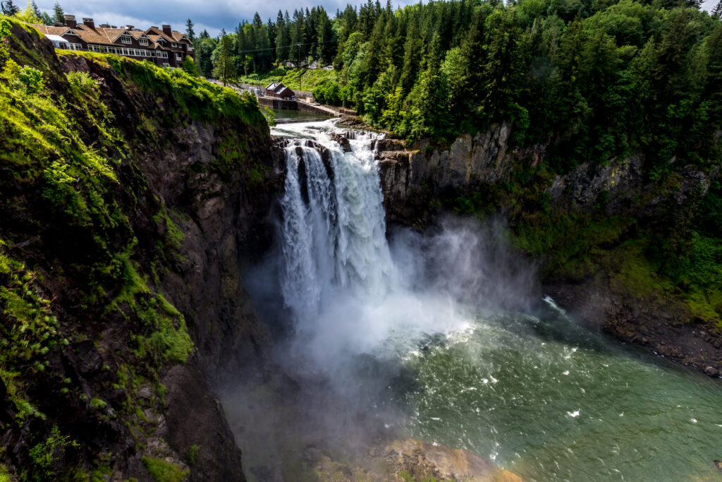
Location: East of Seattle in the town of Snoqualmie
Trail Length: 1.6 miles roundtrip
Elevation Gain: Minimal
Height of Waterfall: 270 feet
Parking Pass: None
Pet-Friendly Trail: Yes
Best Photo Time: Mid-afternoon on a sunny day
Best Time to Visit: Spring during the snowmelt for the best flow, or on weekdays for less of a crowd
Venture along the walkways to the various viewing platforms that showcase the most visited waterfall in Washington, Snoqualmie Falls!
The lower observation deck offers guests a variety of angles to photograph the falls.
The waterfall can also be viewed from overlooks near the Salish Lodge or you can also venture into the four-star lodge for additional views, fine-dining, spa services, and a comfortable room.
If the fall looks familiar, you may have seen it in the opening credits of Twin Peaks!
Spray Falls

Location: Mount Rainier National Park
Trail Length: 4.5 miles round trip to the falls, 6 miles roundtrip to Spray Park
Elevation Gain: 1,100 feet to Spray Falls, 1,700 feet to Spray Park
Height of Waterfall: 354 feet
Parking Pass: National Park Pass
Pet-Friendly Trail: No
Best Time To Visit: Late spring once the snow is melted
Begin by hiking the Wonderland Trail passing the Eagle’s Cliff overlook, where you will have amazing views.
Along the trail, most of the creek crossings have bridges, or you can easily rock-hop your way across the others.
The short spur trail to the falls welcomes you with the mist of Spray Falls. The trail ends at the Spray Falls Viewpoint.
For those who want a longer hike, continue on the main trail to Spray Park and its summer wildflower meadow.
Wallace Falls

Location: Wallace Falls State Park in Gold Bar, WA
Trail Length: 5.6 miles round trip to Upper Falls, 5 miles round trip to Middle Falls
Elevation change: 1,300 feet (1,100 feet from Middle to Upper Falls)
Height of Waterfall: Lower Falls – 212 feet, Middle Falls – 260 feet, Upper Falls – 100 feet
Parking Pass: Washington Discovery Pass
Pet-Friendly Trail: Yes
Best Photo Time: Afternoons
The beautiful Woody Trail meanders along the Wallace River past two waterfalls before it begins to switchback up to the Upper Falls to the end of the trail.
On weekends during the summer, this popular hike is often crowded, so aim to go during the weekdays or in the off-season.
For those who want a less strenuous hike, enjoy the excellent views of both the lower and middle falls before turning around, since there is only a 200-foot elevation change on this section of the trail, and skip the upper falls which has over a thousand feet of elevation gain.
Tip: Parking along Ley Road is not permitted. Early arrival is encouraged since parking is limited.
Silver Falls
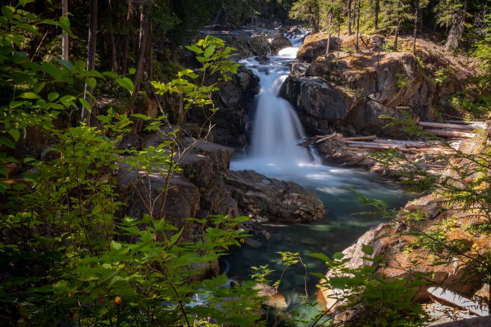
Location: Mount Rainier National Park
Trail Length: 1.4-mile loop along the Eastside Trail; alternately, 3.4 miles from Ohanapecosh Campground
Elevation change: 340 feet
Height of Waterfall: 40 feet
Parking Pass: National Parking Pass
Pet-Friendly Trail: No
Best Time to Visit: May through November
The easy hike through the conifer trees of the Pacific Northwest follows the river through narrow canyons filled with chasms and numerous waterfalls.
The waterfall is not so high at only 40 feet, but it’s beautiful to see and the surrounding foliage is beautiful.
There are several Washington waterfalls worth spotting in Mount Rainier National Park, so consider extending your stay in the area by spending the night at one of 195 sites at the Ohanapecosh Campground.
Twin Falls

Location: Olallie State Park
Trail Length: 2.5 miles via the West Trailhead or alternately 3.75-miles via the Homestead Valley Trailhead
Elevation change: 500 feet for the West Trailhead
Height of Waterfall: 165 feet
Parking Pass: Washington Discovery Pass
Pet-Friendly Trail: Yes, on leash
Stroll along the Snoqualmie River as you make your way to the three waterfalls known as Twin Falls.
The first fall you will see will be visible as you stand on the perch above the river. Then, you can continue hiking to the Twin Fall Canyon Bridge, where there is a two-tier middle drop.
One final section of the hike up several steep switchbacks gives you views of the middle and upper falls.
Panther Creek Falls

Location: Glifford Pinchot National Forest
Trail Length: Less than 1 mile round trip
Elevation change: 200 feet
Height of Waterfall: 172 feet
Parking Pass: NW Forest Pass
Pet-Friendly Trail: Yes
The easy hike to the Panther Creek Falls is well worth it and offers one of the most beautiful, ethereal waterfalls in Washington.
The less than half a mile trail ends at the viewing platform, where you can see the two streams merging to make one waterfall.
Palouse Falls
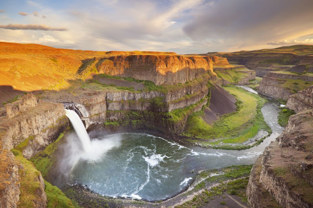
Location: Palouse Falls State Park
Trail Length: Roadside
Height of Waterfall: 180 feet
Parking Pass: Discovery Pass
Pet-Friendly Trail: Yes
Best Photo Spot: Lower observation point
On the west banks of the Palouse River is the official Washington State waterfall, as designated in 2014!
The Palouse Falls can be viewed from the roadside overlook, or you can walk down the two flights of stairs to the rim overlook to see the falls face-on.
A walk to the ends of the roadside overlook gives you additional perspectives of the falls. The gravel paths along the canyon rim also have various views of the falls so you can try taking photos from different unique perspectives.
The falls can also be seen from the Fryxell Overlook within Palouse Falls State Park.
There are plenty of picnic tables around to have a picnic while enjoying the state’s easternmost waterfall and its amazing views.
What to Read Next
More Hiking Inspiration: The Best Hikes Near Seattle
Weekend Getaway Ideas: Best Weekend Getaways from Seattle
Epic Places to Stay: Incredible Treehouse Rentals in Washington State
Seattle City Guide: The Best Things to Do in Seattle

